Tag Archives: battery

Railings and Fog, Battery Spencer

Railings and Fog, Battery Spencer
Fog at the historic Battery Spencer, Marin Headlands

Railings and Fog, Battery Spencer. © Copyright 2021 G Dan Mitchell – all rights reserved.

Fog at the historic Battery Spencer, Marin Headlands

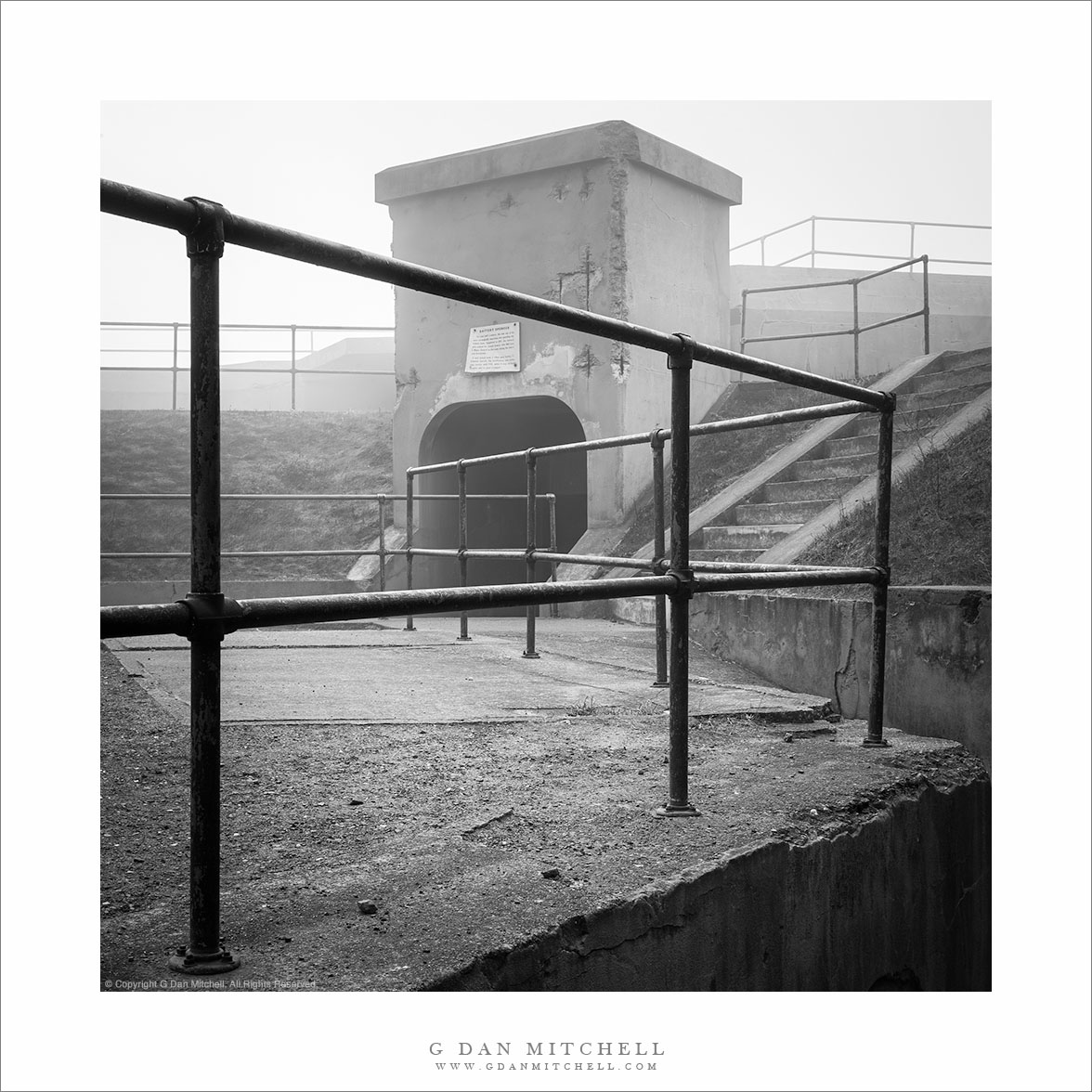
There are old forts and batteries all over the West Coast and especially around the San Francisco Bay Area. Many of them have long histories, though we tend to associate them with World War II, the most recent time when the country through they might be put to use. I know of a number of these sites, but I’m most familiar with those in the Marin Headlands, across the Golden Gate to the north of San Francisco. If you have visited a particular and iconic overlook of the famous bridge you have likely been near to this place.

It is one thing to visit these spots on a sunny day when they are overrun with visitors. But if you go early on a cold and foggy morning you may bet a better sense of what it might have been like to be stationed at one of these sites. When I visited on this fogged-in morning, I was attracted by the relationships and angles of the railings.


G Dan Mitchell is a California photographer and visual opportunist. His book, “California’s Fall Color: A Photographer’s Guide to Autumn in the Sierra” is available from Heyday Books, Amazon, and directly from G Dan Mitchell.

Blog | About | Flickr | FacebookEmail

Links to Articles, Sales and Licensing, my Sierra Nevada Fall Color book, Contact Information.

Scroll down to leave a comment or question.


All media © Copyright G Dan Mitchell and others as indicated. Any use requires advance permission from G Dan Mitchell.

Doorway, Battery Spencer

Doorway, Battery Spencer

Doorway, Battery Spencer. Marin Headlands, California. © Copyright 2007 G Dan Mitchell – all rights reserved.

Morning sun on a doorway at historic Battery Spencer, Golden Gate National Recreation Area.

The Marin Headlands area of the Golden Gate National Recreation Area, just across the bay from San Francisco, is full of old military installations that once guarded the entrance to San Francisco Bay. I’ve been intrigued by these facilities for some time, but my interest was sparked again after seeing the San Francisco Opera production of Wagner’s “Ring” cycle earlier this year, in which some sets were inspired by these structures.

Battery Spencer is one of the most accessible of these sites, though in some ways it may be overlooked since many people simply walk through or past it on their way from the parking area to a very popular and spectacular viewpoint just above the north end of the Golden Gate Bridge. But in the right conditions of atmosphere and light this area can provide a lot of interesting photographic possibilities. This open doorway, lit my morning light, is along a passageway between a number of structures that are half buried in the hillside here.

G Dan Mitchell Photography
About | Flickr | Twitter | FacebookGoogle+ | 500px.com | LinkedIn | Email

Text, photographs, and other media are © Copyright G Dan Mitchell (or others when indicated) and are not in the public domain and may not be used on websites, blogs, or in other media without advance permission from G Dan Mitchell.

(Basic EXIF data may be available by “mousing over” large images in posts when this page is viewed on the web. Leave a comment if you want to know more.)

Rusted Gate and Concrete Wall, Battery 129

Rusted Gate and Concrete Wall, Battery 129

Rusted Gate and Concrete Wall, Battery 129. Golden Gate National Recreation Area, California. July 14, 2011. © Copyright 2011 G Dan Mitchell – all rights reserved.

Rusted gate against a weathered concrete wall at the entrance to a tunnel at Battery 129, Golden Gate National Recreation Area.

At the north end of the Golden Gate Bridge, Conzelman Road leads up into the Marin Headlands along the San Francisco Bay side of the ridge. This road is a favorite place for overlooking the Golden Gate and its famous bridge along with a large expanse of San Francisco and its Bay and points east. In mid-July the road was not accessible from the usual spot near the end of the bridge, so I detoured around towards the “back entrance” via the road to Rodeo Beach. From this road I turned up into the hills and joined Conzelman near its summit. I made a few foggy photographs of the Bay, but my main interest was in trying to find photographs in the old batteries and other abandoned military facilities along the ridge running out toward Point Bonita.

At the summit of the hill, before the road becomes very narrow and many people turn back, is “Battery 129.” There are several tunnels into this facility from alongside the road and a separate route leads up the hill to the old structures on the summit. I took one of the two tunnels under the hill and as I entered the second section I saw this old metal gate against a weathered concrete wall, illuminated by light leaking in from the end of the tunnel.

G Dan Mitchell Photography
About | Flickr | Twitter | FacebookGoogle+ | 500px.com | LinkedIn | Email

Text, photographs, and other media are © Copyright G Dan Mitchell (or others when indicated) and are not in the public domain and may not be used on websites, blogs, or in other media without advance permission from G Dan Mitchell.

(Basic EXIF data may be available by “mousing over” large images in posts. Leave a comment if you want to know more.)

Offshore Fog Bank, Marin Headlands

Offshore Fog Bank, Marin Headlands

Offshore Fog Bank, Marin Headlands. Golden Gate National Recreation Area, California. July 14, 2011. © Copyright 2011 G Dan Mitchell – all rights reserved.

Offshore fog lies beyond Point Bonita and Rodeo Beach and the Marin Headlands of the Golden Gate National Recreation Area.

I was surprised to find a clear view like this during my mid-July visit to the Marin Headlands of the Golden Gate National Recreation Area (GGNRA) across the Bay from San Francisco. I had almost decided to stay home or go elsewhere based on weather reports that had the coast completely socked in my dense fog for most of the day. Indeed, it was foggy as I passed through San Francisco and drove across the Golden Gate Bridge. The fog was high, and I could see some distance beneath it, but it was still a rather gray day.

Since the lower section of Conzelman Road, the normal quick and scenic route up into the headlands, was closed for construction, I took that alternate route that passes through a tunnel to come out near Rodeo Beach. I turned left up the hill to reach the upper section of the road. After photographing near Battery 129 for a while, the sun began to break through the fog, and I was surprised to find a fairly clear patch just outside the Golden Gate.

The photograph shows the last section of the headlands as the hills drop towards the historic fort and batteries near the Point Bonito light house, which is barely visible at the end of the peninsula on the left. The line of surf at the upper right is Rodeo Beach, a popular spot with Bay Area folks.

G Dan Mitchell Photography
About | Flickr | Twitter | FacebookGoogle+ | 500px.com | LinkedIn | Email

Text, photographs, and other media are © Copyright G Dan Mitchell (or others when indicated) and are not in the public domain and may not be used on websites, blogs, or in other media without advance permission from G Dan Mitchell.

(Basic EXIF data may be available by “mousing over” large images in posts. Leave a comment if you want to know more.)