“Red Rock Sunset” — Sunset light on red rock formations near Fruita, Capitol Reef National Park.
This spot is obviously full of spectacular scenery, though it was a bit tricky to photograph near sunset. One of the “problems” actually turned out to be a plus. There was some overcast that muted the light, but the light was still strong enough to be softly directional, especially on the more distant cliffs. A second issue is geological. The area is on an inclined formation that rises to the west, so the sun actually drops behind the uplifted western horizon a bit earlier than true sunset.
The color was astonishingly red in this sunset light, especially since the soft light reduced harsh shadows and highlights. I don’t often include roads in my landscape photographs, but in this case, a) it was unavoidable and b) it produced a useful leading line heading toward the groves of trees and the campground at Fruita.
Leave a comment or question using the form. (If you are reading this on the home page, click the article title to see the full article and the comment form.
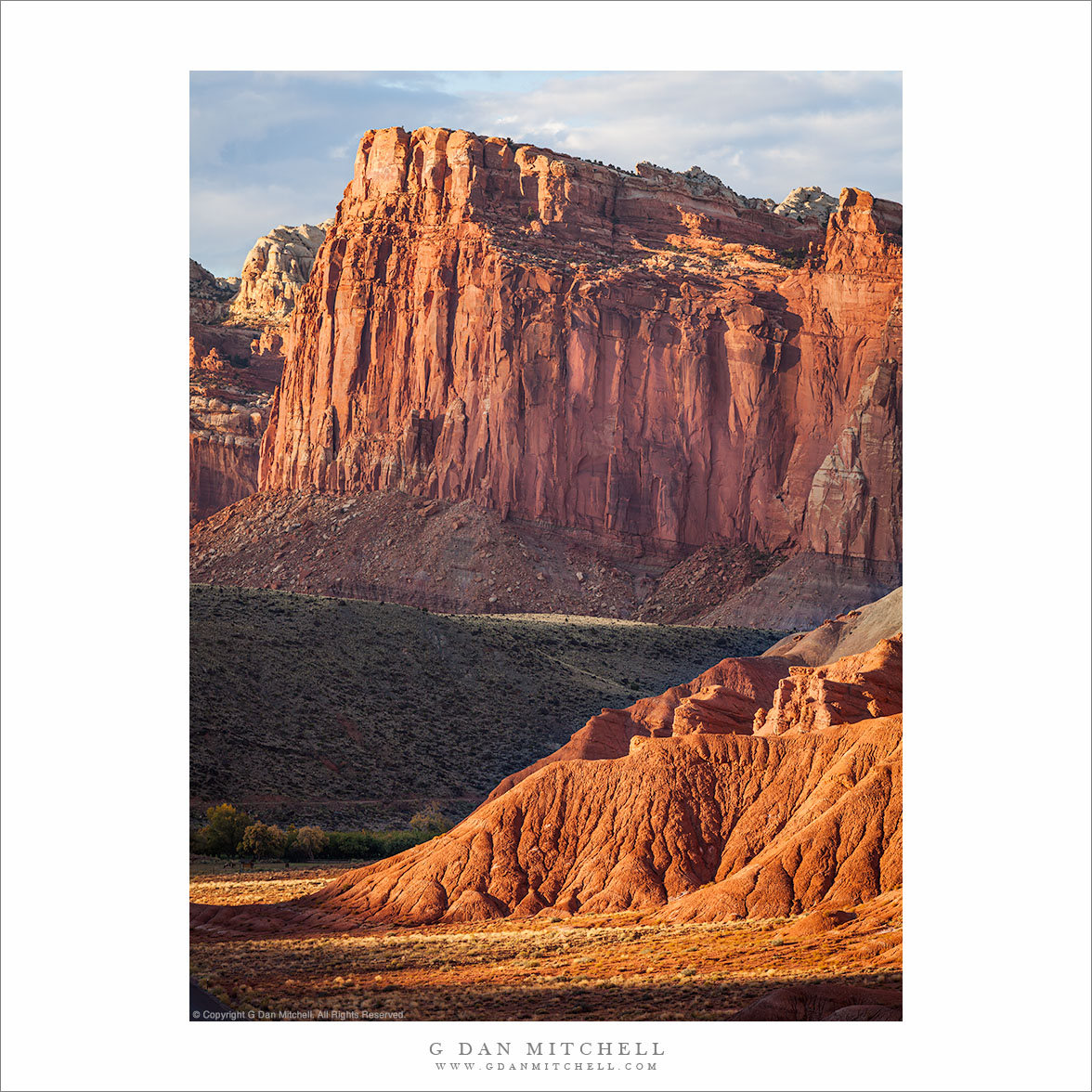
“Evening, Near Fruita” — Evening light on the cliffs and hills of Capitol Reef National Park near Fruita
I had just arrived at Fruita (pronounced “Fruit-ah”) at Capital Reef National Park in the afternoon, after driving from near Kanab via a long gravel back road. After meeting a friend here and setting up camp it was late afternoon, and there was just time to head out and do some brief photography nearby before the day ended. We had an idea about heading into one of the west side canyons that are accessible by the popular (mostly) paved road, but we didn’t get nearly that far before we saw this beautiful evening light. Actually, we were probably not even a quarter-mile from the campground!
The light in this part of the park often poses a bit of a challenge late in the day. While one might look for late golden hour sun on these west-facing sandstone cliffs and peaks, the land rises from here toward the west, causing the sun to disappear from this area earlier than you might expect. But we got lucky, as broken clouds softened and warmed the light as the last sun touched these rocks just as we arrived at this spot. It is the kind of place I might usually drive past, as it is almost too obvious of a photographic location. However, I readily admit to stopping at iconic locations when the light is special, as it surely was on this evening.
Leave a comment or question using the form. (If you are reading this on the home page, click the article title to see the full article and the comment form.
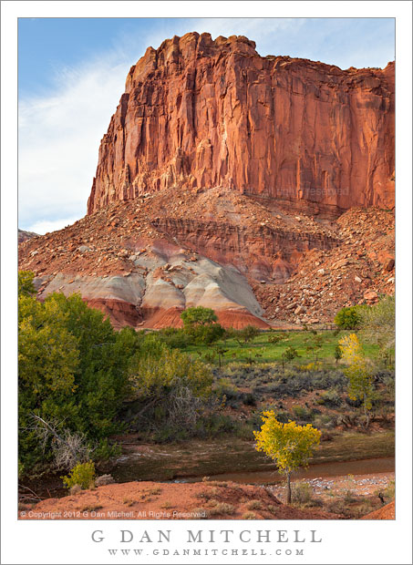
A sandstone tower stands above the Fruita District orchards in early evening light, Capitol Reef National Park
These sandstone plateaus and mesas seem characteristic of this front-country area of Capitol Reef National Park, and they are perhaps the most striking visual icon of your approach to the park from the town of Torrey, Utah, to the west. The Fruita District is the most accessible area of the park, being right alongside the main east-west highway that passes through the park. It features some picturesque sites and sights that are enough to make almost anyone pull over and look, including the old orchards that apparently gave the area its name and the accessible petroglyphs on low cliffs that run along the road. (Although this portion of the park is quite accessible once you are out here and driving across Utah, most of the park is anything but easily accessible, and getting to other places within its boundaries can involve some very long drives on some fairly bad roads, plus some hiking. I’m fine with that! ;-)
I made this photograph late in the day, after we had done a bit of exploring along the main tourist route into the park, the largely paved road towards Capitol Gorge and other nearby points. Late in the day I happened to spot this little conjunction of creek and fall-color tree and green grass and red rock cliffs as we were about to leave the park.
G Dan Mitchell is a California photographer and visual opportunist whose subjects include the Pacific coast, redwood forests, central California oak/grasslands, the Sierra Nevada, California deserts, urban landscapes, night photography, and more. Blog | About | Flickr | Twitter | Facebook | Google+ | 500px.com | LinkedIn | Email
Sandstone towers and cliffs in evening light, Capitol Reef National Park
By comparison to some of the other well-known Utah national parks, it seems to me that Capitol Reef is perhaps a bit more difficult to get to know. Oddly, this might be partially because it is so easy to experience it very superficially. A main highway passes right though the park, and a number of the characteristic and iconic features are visible from the highway or by barely leaving it: the well-known orchards, accessible examples of rock art, large and impressive sandstone walls and towers, the Fremont River. Other features are neatly containing along an impressive “scenic drive” with some popular trails. But it seems that the steps to see additional aspects of the park are bigger than at some other parks. For example, while most Yosemite visitors think of The Valley as the park, it isn’t really all that difficult to drive paved roads to Glacier Point, redwood groves, or even the summit of the Sierra. But to go a bit further at Capitol Reef you might have to drive through a river, have four-wheel drive, ask someone about some relatively unknown canyon, drive for many miles on gravel roads.
My first visit to this park was limited to the most accessible features, as we were passing through on our way to another place. We stopped briefly to see the rock art, and I saw those iconic orchards of Fruita. On the second visit, we had more time – we were in the area of several days – and we spent time on the “scenic drive,” did a few of the hikes, and poked around the fringes of these area. We even drove the dozens of miles down that east side gravel road and took a long drive on less-used roads to return to where we started. On a subsequent trip, we asked around a bit, and ended up poking into a canyon where we were the only visitors and walking along a route high in the mountains on a sub-freezing morning. This photograph comes from the intermediate experience of that second trip. Although there was (and still is!) much that I don’t know about this huge and diverse park, by this point I was starting to get a sense of the rhythms of light and so forth, and this enable us to be at this (accessible) location at the right hour as the day came to an end.
G Dan Mitchell is a California photographer whose subjects include the Pacific coast, redwood forests, central California oak/grasslands, the Sierra Nevada, California deserts, urban landscapes, night photography, and more. Blog | About | Flickr | Twitter | Facebook | Google+ | 500px.com | LinkedIn | Email
Photographer and visual opportunist. Daily photos since 2005, plus articles, reviews, news, and ideas.
Manage Consent
To provide the best experiences, we use technologies like cookies to store and/or access device information. Consenting to these technologies will allow us to process data such as browsing behavior or unique IDs on this site. Not consenting or withdrawing consent, may adversely affect certain features and functions.
Functional
Always active
The technical storage or access is strictly necessary for the legitimate purpose of enabling the use of a specific service explicitly requested by the subscriber or user, or for the sole purpose of carrying out the transmission of a communication over an electronic communications network.
Preferences
The technical storage or access is necessary for the legitimate purpose of storing preferences that are not requested by the subscriber or user.
Statistics
The technical storage or access that is used exclusively for statistical purposes.The technical storage or access that is used exclusively for anonymous statistical purposes. Without a subpoena, voluntary compliance on the part of your Internet Service Provider, or additional records from a third party, information stored or retrieved for this purpose alone cannot usually be used to identify you.
Marketing
The technical storage or access is required to create user profiles to send advertising, or to track the user on a website or across several websites for similar marketing purposes.