“Mining Ruins, Death Valley National Park” — Ruins of an miner’s cabin, Death Valley National Park.
Among American national parks, Death Valley is known for extensive and diverse evidence of human presence. There are traces of ancient people from the time of European immigrants and their descendants. More recently, members of the latter group came to this landscape as prospectors and miners. Today, even in the most remote parts of the park, you can find their decaying remnants, like this old cabin.
I have visited this site for years, and each time I ponder what it must have been like to live and work in a place like this. It is high in desert mountains, without trees or water, and most people would regard it as desolate. Nearby is a small mine that appears to have been worked by hand. Over the years that I have visited the tiny cabin has continued to deteriorate, and I cannot imagine that it will last much longer.
“Holyrood Abbey Ceiling” — The ceiling vaults of the Holyrood Abbey, Edinburgh, Scotland.
Edinburgh is a busy city, popular with tourists — and there is quite a lot to see there. A lot of the main attractions are found in the Old Town area along the Royal Mile that runs between the hilltop Edinburgh Castle and the Holyrood Palace, a residence of British royalty. The ruins of the Holyrood Abbey are on the grounds of the palace.
The Abbey dates to the 12th century, The suffix “rood” refers to the Holy Cross, There were several versions of the place, and this is the last, most architecturally advanced version. In addition to its religious significance, the site is also connected to Scottish history. The structure eventually fell into disuse and was neglected. An ill-advised attempt to restore and strengthen it ended up adding too much weight and portions collapsed, leaving the ruins that we see today.
G Dan Mitchell is a California photographer and visual opportunist. His book, “California’s Fall Color: A Photographer’s Guide to Autumn in the Sierra” is available from Heyday Books, Amazon, and directly from G Dan Mitchell.
“Oban, Scotland” — An elevated view of central Oban, Scotland, from near McCaig’s Tower.
Judging from our brief 2-night stay in this Scottish town, Oban is a charming place. It sits right on the waterfront and, from what I could see, mostly lines the shoreline and nearby hills. My impression is that the town is largely connected to three things: tourism, water-related industry (ferries, tours, and fishing), and whisky. (The well-known and highly-regarded Oban Distillery is right in town). Because we were there before the prime summer season the impact of tourists was perhaps less than it might be late.
We had two nights in Oban, and we walked around a lot on our full day in town. We had seen McCaig’s Tower, the old circular structure on top of the nearby hill, so we decided to do the steep but short walk up there. This photograph comes from that walk, and it looks out over the town from that hillside, with a view towards more distant hills and islands.
G Dan Mitchell is a California photographer and visual opportunist. His book, “California’s Fall Color: A Photographer’s Guide to Autumn in the Sierra” is available from Heyday Books, Amazon, and directly from G Dan Mitchell.
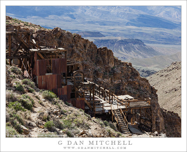
The abandoned Skidoo Mill, high in the Panamint Mountains of Death Valley National Park
I have been out to the site of the old ghost town of Skidoo a few times. Oddly perhaps, snow has played a part in more than half of my visits—not what you might expect for a desert region like Death Valley. The first time I went there I really did not know much about the place at all, and I drove the nine mile gravel road more or less on a whim, arriving at the broad valley where the main town was, finding little there, poking around a bit, and leaving, a bit disappointed. (I did have a chance to investigate some other historical sites in the area on the same trip, so in the end I didn’t feel cheated.) More recently I visited last winter, during a very cold trip to the park when I encountered sub-freezing temperature down in Death Valley itself and colder temperature well down into the teens up here. Parts of the road were covered by shallow snow, and it was a quiet and lonely experience to be out there alone in the snow. This time I poked around a bit more, exploring some side trails and nearby ridges, until I decided that it was best not to push too far with the snow on the ground.
This past April we were there again, on a day full of interesting experiences and adventures. I often spend at least a day up in the Panamint Range when I visit the park, and I always find new and interesting things, but I don’t think I’ve ever encountered such a range of conditions and subjects in a single day before. We started before dawn and had a brief moment of sunrise light before the clouds of an incoming storm turned out the lights. Very soon we began to see snow flurries along the Panamint ridge and other summits, and soon after visiting one historic site it began to snow in earnest. We headed toward a higher location and finally had to back down as the snow continued to fall. Surprisingly, in these cold conditions and snow we found… abundant wildflowers! We stopped several times to photograph the unexpected display, and then decided to make the side trip to Skidoo as the storm passed and the sun came out. Once there we pushed out past the town site to the location of the old mill, where ore from the mines was processed. The mill, long abandoned and deteriorating now, is an astonishing thing. Its location is unexpected and stunning. It sits right below the crest of a steep ridge and the structure stretches down toward a deep valley below—and the entire site overlooks a vast and arid desert landscape, a bit of which is visible in this photograph. Even more amazing, this mill was powered by water, not at all what you would expect in such a dry and desolate place. But the miners ran a pipeline over 20 miles from a spring elsewhere in the high Panamints to get water to supply power and for the domestic use of the town’s residents.
G Dan Mitchell is a California photographer and visual opportunist whose subjects include the Pacific coast, redwood forests, central California oak/grasslands, the Sierra Nevada, California deserts, urban landscapes, night photography, and more. Blog | About | Flickr | Twitter | Facebook | Google+ | 500px.com | LinkedIn | Email
Photographer and visual opportunist. Daily photos since 2005, plus articles, reviews, news, and ideas.
Manage Consent
To provide the best experiences, we use technologies like cookies to store and/or access device information. Consenting to these technologies will allow us to process data such as browsing behavior or unique IDs on this site. Not consenting or withdrawing consent, may adversely affect certain features and functions.
Functional
Always active
The technical storage or access is strictly necessary for the legitimate purpose of enabling the use of a specific service explicitly requested by the subscriber or user, or for the sole purpose of carrying out the transmission of a communication over an electronic communications network.
Preferences
The technical storage or access is necessary for the legitimate purpose of storing preferences that are not requested by the subscriber or user.
Statistics
The technical storage or access that is used exclusively for statistical purposes.The technical storage or access that is used exclusively for anonymous statistical purposes. Without a subpoena, voluntary compliance on the part of your Internet Service Provider, or additional records from a third party, information stored or retrieved for this purpose alone cannot usually be used to identify you.
Marketing
The technical storage or access is required to create user profiles to send advertising, or to track the user on a website or across several websites for similar marketing purposes.