Tag Archives: flood

Flooded Forest

Flooded Forest
A section of Yosemite Valley forest flooded by spring snow runoff.

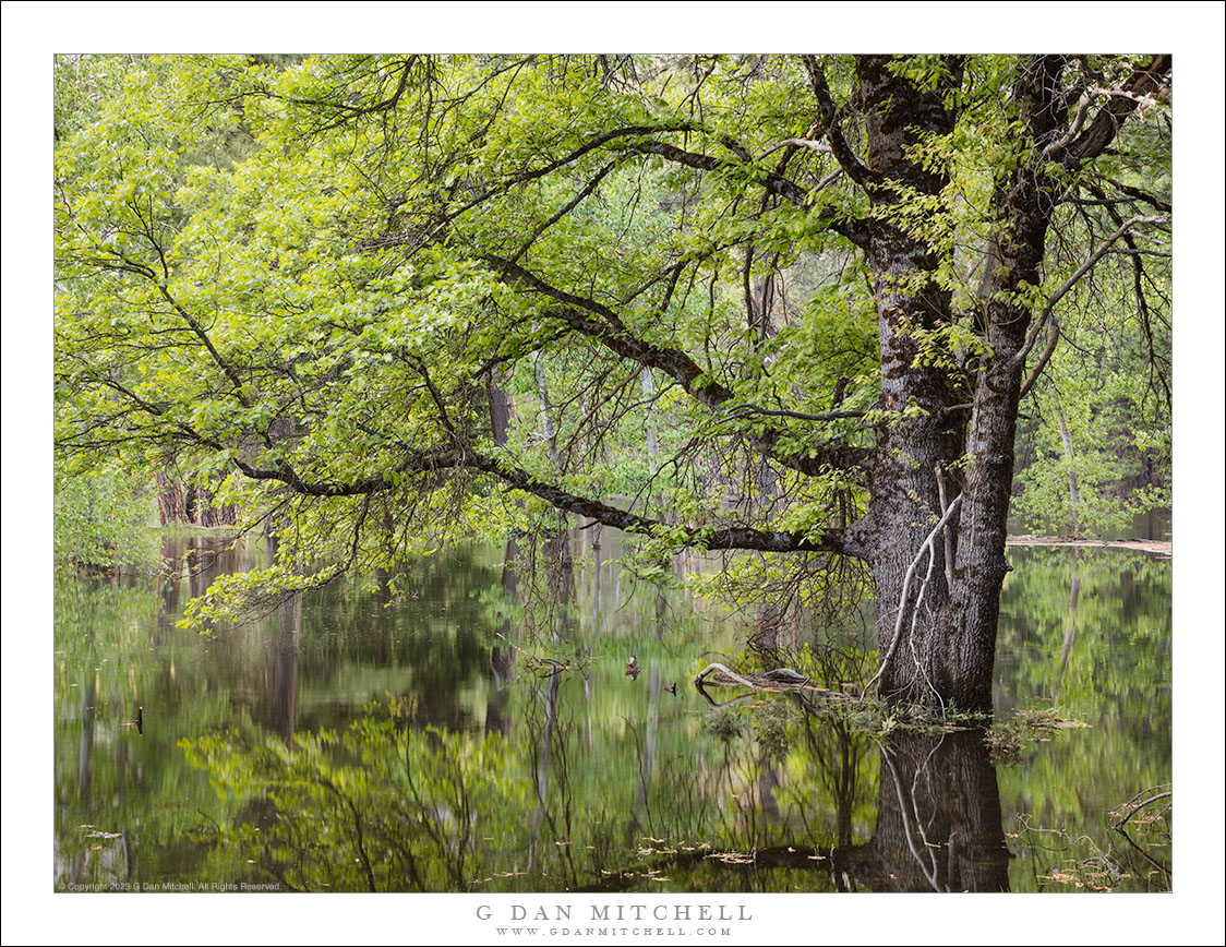
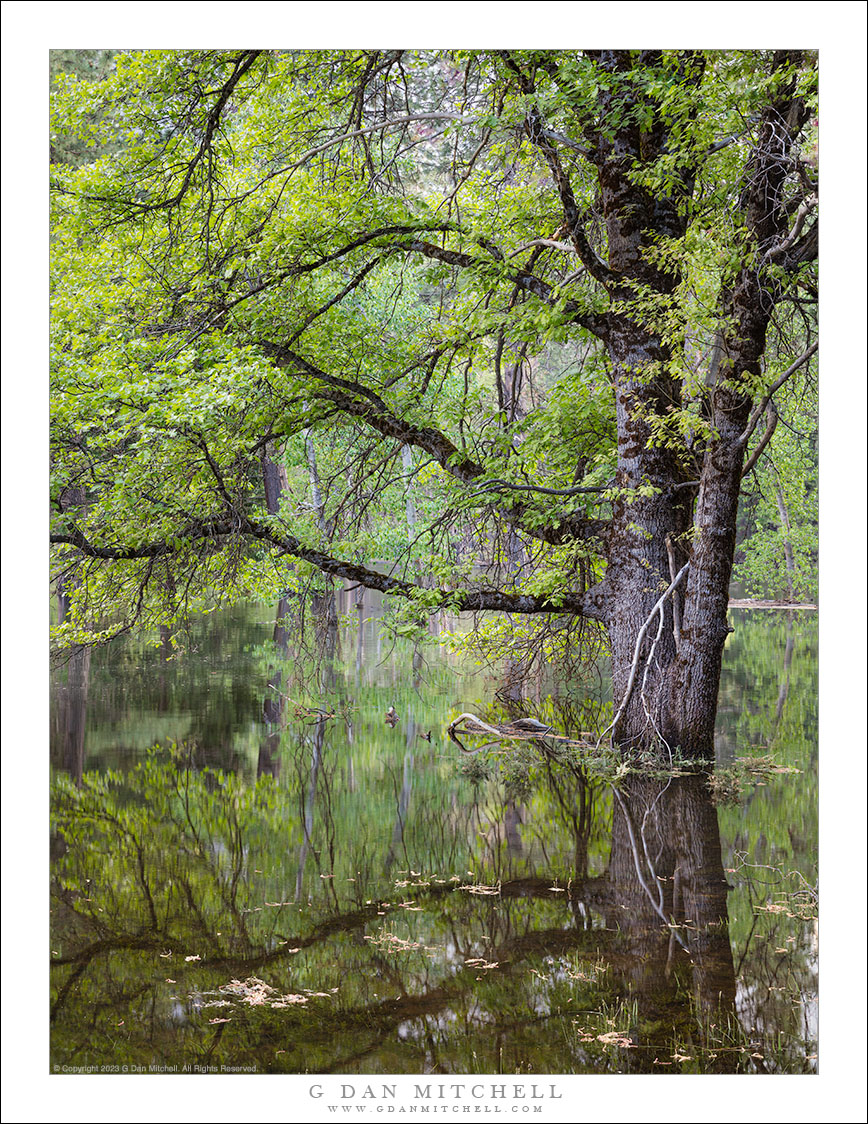
Flooded Forest. © Copyright 2023 G Dan Mitchell.

A section of Yosemite Valley forest flooded by spring snow runoff.

There is often some degree of flooding in the Sierra during snow-melt season, and hiking can involve jumping streams, detouring around seasonal ponds, and occasional walking through some pretty muddy terrain. But this year is an extremely case. When I visited Yosemite Valley in late May there was flooding all over — trails that disappeared under water, meadows that had turned into lakes, and water flowing everywhere.

This particular spot is typically a sort of open forest with some grassy areas interspersed with the trees. But this time it looked more like a swamp, with water covering the perimeter trail and many trees standing in this temporary lake. The upside? Quite a few, including the beautiful reflections of the trees. Downsides? Mosquitos!


G Dan Mitchell is a California photographer and visual opportunist. His book, “California’s Fall Color: A Photographer’s Guide to Autumn in the Sierra” is available from Heyday Books, Amazon, and directly from G Dan Mitchell.

Blog | About | Twitter | Flickr | FacebookEmail

Links to Articles, Sales and Licensing, my Sierra Nevada Fall Color book, Contact Information.

Scroll down to leave a comment or question. (Click this post’s title first if you are viewing on the home page.)


All media © Copyright G Dan Mitchell and others as indicated. Any use requires advance permission from G Dan Mitchell.

Trees in Flooded Meadow

Trees in Flooded Meadow
Yosemite Valley trees stand in a meadow flooded with spring snow run-off.

Trees in Flooded Meadow. © Copyright 2023 G Dan Mitchell.

Yosemite Valley trees stand in a meadow flooded with spring snow run-off.

At first glance, this photograph might look like something from the Florida Everglades. But as the spring snow melt switches into high gear, many typically dry places in California are distinctly wet. During my pre-Memorial-Day visit to Yosemite Valley many meadows and even low forest areas were flooded by the rising Merced River. More than once as I hiked in the Vally my trails simply disappeared under water!

I know this spot well and have photographed here often in the past — when it was a dry forest along the banks of the Merced. But this week the water came almost to the roadway and flooded the trail in places. In fact, I had to set up on some rather spongy and unsteady ground in order to frame this scene!


G Dan Mitchell is a California photographer and visual opportunist. His book, “California’s Fall Color: A Photographer’s Guide to Autumn in the Sierra” is available from Heyday Books, Amazon, and directly from G Dan Mitchell.

Blog | About | Twitter | Flickr | FacebookEmail

Links to Articles, Sales and Licensing, my Sierra Nevada Fall Color book, Contact Information.

Scroll down to leave a comment or question. (Click this post’s title first if you are viewing on the home page.)


All media © Copyright G Dan Mitchell and others as indicated. Any use requires advance permission from G Dan Mitchell.

Panamint Lake

Panamint Lake
Panamint Lake spreads across Panamint Valley following heavy winter rains

Panamint Lake. © Copyright 2019 G Dan Mitchell – all rights reserved.

Panamint Lake spreads across Panamint Valley following heavy winter rains.

Death Valley National Park visitors who arrive from the west or southwest almost certainly drive through Panamint Valley — whether traversing a good part of its length when driving north from Ridgecrest and Trona arriving after driving across from Owens Valley and US 395. The area was not originally part of the park but was added more recently. Despite being framed by big, rugged mountain ranges on either side, it is more typically a place people drive “through” rather than “to.”

It is also generally a very dry place. But near its upper end there is a typical desert playa… which necessarily implies that the area is periodically flooded during wet periods. This spring I passed through twice on visits that were about a month apart. The first time followed a very wet period and the usually dry playa was covered by a very large, shallow lake… of which there were virtually no traces one month later.


G Dan Mitchell is a California photographer and visual opportunist. His book, “California’s Fall Color: A Photographer’s Guide to Autumn in the Sierra” is available from Heyday Books and Amazon.

Blog | About | Flickr | FacebookEmail

Links to Articles, Sales and Licensing, my Sierra Nevada Fall Color book, Contact Information.


All media © Copyright G Dan Mitchell and others as indicated. Any use requires advance permission from G Dan Mitchell.

Spring Flooding, Tuolumne Meadows

Spring Flooding, Tuolumne Meadows

Spring Flooding, Tuolumne Meadows. Yosemite National Park, California. May 4, 2014. © Copyright 2014 G Dan Mitchell – all rights reserved.

The Tuolumne River overflows its banks on a spring evening, Tuolumne Meadows

This is another, slightly different view of a scene that I shared recently, photographed at Tuolumne Meadows on the weekend when Tioga Pass Road over the Sierra crest opened for the 2014 season. As is my habit, I broke free and made it up there to celebrate the beginning of a new high country season. It was a quick trip—a 21 hour 550 mile drive that took me across the range to the Mono Lake area and some nearby sights on the “east side.” Later in the day I reversed course and headed back up to Tioga Pass and began my homeward trip, stopping to spend a good part of the evening in Tuolumne Meadows, where strong wind blew as the golden hour light began to develop.

This scene is full of things that I know well. I have visited the general area of Tuolumne Meadows since I was a child and my father took me and one of my brothers up there on the first camping trip that I can remember. Every spring (or early summer in wet years) when I return I look for this area of the meadow where the Tuolumne River overflows its banks and produces a temporary lake, even in a very dry year like this one. On a number of occasions I have hiked on a trail that crosses from right to left just below the bright granite peak in the upper left, heading for a pass below Ragged Peak and then on to Young Lakes, which lie just beyond that highest ridge. (Just below and to the left of the granite peak lies a beautiful area of subalpine meadow with scattered rocks and extensive fields of lupine.) On this evening there were few people in the meadow, as the campground was not yet open and not many people were still up here so late in the day, so I was able to wait quietly for the clouds and the light to line up just right.

G Dan Mitchell is a California photographer and visual opportunist whose subjects include the Pacific coast, redwood forests, central California oak/grasslands, the Sierra Nevada, California deserts, urban landscapes, night photography, and more.
Blog | About | Flickr | Twitter | FacebookGoogle+ | 500px.com | LinkedIn | Email

Text, photographs, and other media are © Copyright G Dan Mitchell (or others when indicated) and are not in the public domain and may not be used on websites, blogs, or in other media without advance permission from G Dan Mitchell.