Tag Archives: rhyolite

Amargosa Sky, Morning

Amargosa Sky, Morning
Early morning sky above Amargosa Valley and the Amargosa Range mountains.

Amargosa Sky, Morning. © Copyright 2012 G Dan Mitchell – all rights reserved.

Early morning sky above Amargosa Valley and the Amargosa Range mountains.

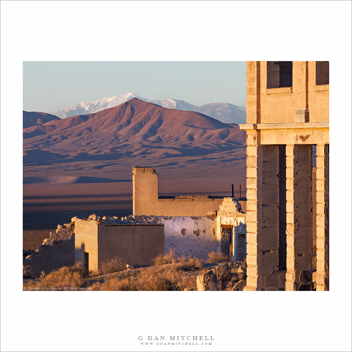
Although this photograph is from eight years ago, I recall this morning as if it were last week. One day during my annual spring sojourn in Death Valley I decided to get up early and drive out of the park to the east, passing though the triangle of the park that extends into Nevada to get to one of the many ghost town sites in this region. The place gets a fair number of visitors — to the extent that it has more recently been fenced off to protect it — but on this morning I was just about the only person there.

Although I was there mainly to photograph the decaying structures, the remnants of this town sit on the edge of a vast expanse of open desert landscape. This view looks across the wide Amargosa River Valley toward the Amargosa Range that runs along a good part of the eastern boundary of the park. The light was stunning just after sunrise, and thin clouds were visible for a while until stronger light made them less visible as the sun rose higher.


G Dan Mitchell is a California photographer and visual opportunist. His book, “California’s Fall Color: A Photographer’s Guide to Autumn in the Sierra” is available from Heyday Books and Amazon.

Blog | About | Flickr | FacebookEmail

Links to Articles, Sales and Licensing, my Sierra Nevada Fall Color book, Contact Information.

Scroll down to leave a comment or question.


All media © Copyright G Dan Mitchell and others as indicated. Any use requires advance permission from G Dan Mitchell.

Rhyolite, Amargosa Valley, Telescope Peak

Rhyolite, Amargosa Valley, Telescope Peak

Rhyolite, Amargosa Valley, Telescope Peak. Near Death Valley National Park. April 1, 2014. © Copyright 2014 G Dan Mitchell – all rights reserved.

Telescope Peak, the Amargosa Mountains, and the Amargosa Valley seen beyond the ghost town of Rhyolite Nevada

I first visited the fabled ghost town of Rhyolite, Nevada perhaps a decade ago. I lies outside of Death Valley National Park, not too far from Beatty, Nevada. The place has existed in a state of mostly natural decay in the decades since it was abandoned. The story is that it was once a very successful and busy mining town, but as happens to virtually all such places, the mines played out and the town died. Not a lot is left at this point, though there are a few very interesting structures. Their size gives evidence of what the town must have been: a railroad station, a crumbling bank building, the remains of a large schoolhouse, and more.

When I first visited Rhyolite the place was pretty much what it was, and you could go just about anywhere you wanted to go. Within a few years fencing began to appear around some of the more dangerous structures—tall ruins of stone walls that are eventually going to fall. As time passed more and more fences were erected, and today many of the old buildings are off-limits. In a way this disappoints me, but given the increasing number of visitors and the increasingly fragile state of the town and its structures, I’m will to accept these limitations as a way to slow the eventual decay of the place. I’ve photographed at various times of day and in a range of conditions, but I still like dawn the best here. When the conditions are right, the sun comes up over a low ridge to the east and its light strikes the old bank building and other structures in the town just after it reaches the Amargosa Range and the summit of distant Telescope Peak, the highest point in Death Valley National Park.

G Dan Mitchell is a California photographer and visual opportunist whose subjects include the Pacific coast, redwood forests, central California oak/grasslands, the Sierra Nevada, California deserts, urban landscapes, night photography, and more.
Blog | About | Flickr | Twitter | FacebookGoogle+ | 500px.com | LinkedIn | Email

Text, photographs, and other media are © Copyright G Dan Mitchell (or others when indicated) and are not in the public domain and may not be used on websites, blogs, or in other media without advance permission from G Dan Mitchell.

Rhyolite Ghost Casino

Rhyolite Ghost Casino - The "Rhyollite Ghost Casino" was originally the railroad station in what is now the ghost town of Rhyolite, Nevada
The "Rhyollite Ghost Casino" was originally the railroad station in what is now the ghost town of Rhyolite, Nevada

Rhyollite Ghost Casino. Rhyolite, Nevada. January 4, 2012. © Copyright 2012 G Dan Mitchell – all rights reserved.

The “Rhyollite Ghost Casino” was originally the railroad station in what is now the ghost town of Rhyolite, Nevada.

This building in the ghost town of Rhyolite was originally a (very expensive) railway station that was abandoned when the town itself was abandoned after the nearby mines ran out of profitable ore in the early 1900s. According to several sources I have read, the building was then turned into a bar and casino, and many years later was for a time a curio shop and museum. Today it is boarded up and behind cyclone fences – more off-limits than almost any other structure in the ghost town.

I would live to get beyond the fencing and photograph this building more closely. It looks, in some ways, surprisingly modern for something that was constructing in the middle of nowhere about a century ago, and there are a number of interesting elements in the architecture. (I have photographed some of them, and eventually I’ll perhaps post a few.) The green sign on the front of the building appears to be a repurposed sign from the railroad station days. Underneath the fading “Rhyolite Ghost Casino” lettering, barely readable in this photograph, is and older sign declaring in larger print, “Rhyolite.” A walk around the structure reveals other interesting details, including one area that looks like it might have been a booth for a fortune-teller.

G Dan Mitchell is a California photographer whose subjects include the Pacific coast, redwood forests, central California oak/grasslands, the Sierra Nevada, California deserts, urban landscapes, night photography, and more.
Blog | About | Flickr | Twitter | FacebookGoogle+ | 500px.com | LinkedIn | Email

Text, photographs, and other media are © Copyright G Dan Mitchell (or others when indicated) and are not in the public domain and may not be used on websites, blogs, or in other media without advance permission from G Dan Mitchell.

Rhyolite Ghost Town, Amargosa Valley and Mountains

Rhyolite Ghost Town, Amargosa Valley and Mountains - The ruins of the ghost town of Rhyolite, Nevada stand above the Amargosa Valley, with the Amargosa Range and Death Valley National Park in the distance.
The ruins of the ghost town of Rhyolite, Nevada stand above the Amargosa Valley, with the Amargosa Range and Death Valley National Park in the distance.

Rhyolite Ghost Town, Amargosa Valley and Mountains. Rhyolite, Nevada. January 4, 2012. © Copyright 2012 G Dan Mitchell – all rights reserved.

The ruins of the ghost town of Rhyolite, Nevada stand above the Amargosa Valley, with the Amargosa Range and Death Valley National Park in the distance.

While there can be some moments of beautiful and colorful sunrise light at the ghost town of Rhyolite, Nevada – and I was there for it – this early morning light from a short time later probably gives a more true sense of what the place tends to look like during the winter months. (Even here, the high, thin clouds soften the scene a bit – it is often quite cloudless.)

From what I understand, Rhyolite sprang up in the very early 1900s after gold was discovered nearby. During the short life of the town, measured in no more than decades, it was reportedly the second largest city in southern Nevada. It featured banks (two of which are seen in this photograph), a railroad station (abandoned but still present and located behind my camera position), newspapers, an impressive school house, and thousands of residents. It was all largely abandoned in the first half of the 1900s and most of the buildings are gone, though traces of them and the old roads they lined can still be found here and there. A few large buildings in the center of the town still more or less stand, in varying states of decay. The building on the right was the Cook Bank. Another bank was located where the white walls are a bit further in the distance. The town school house is the furthest building. The whole town overlooked the Amargosa Valley, where the current boundary of Death Valley National Park lies. Beyond that, an inside the park, are the Amargosa Range and in the far distance the ridge of the Panamint Range and the summit of 11,000+’ Telescope Peak.

G Dan Mitchell is a California photographer whose subjects include the Pacific coast, redwood forests, central California oak/grasslands, the Sierra Nevada, California deserts, urban landscapes, night photography, and more.
Blog | About | Flickr | Twitter | FacebookGoogle+ | 500px.com | LinkedIn | Email

Text, photographs, and other media are © Copyright G Dan Mitchell (or others when indicated) and are not in the public domain and may not be used on websites, blogs, or in other media without advance permission from G Dan Mitchell.