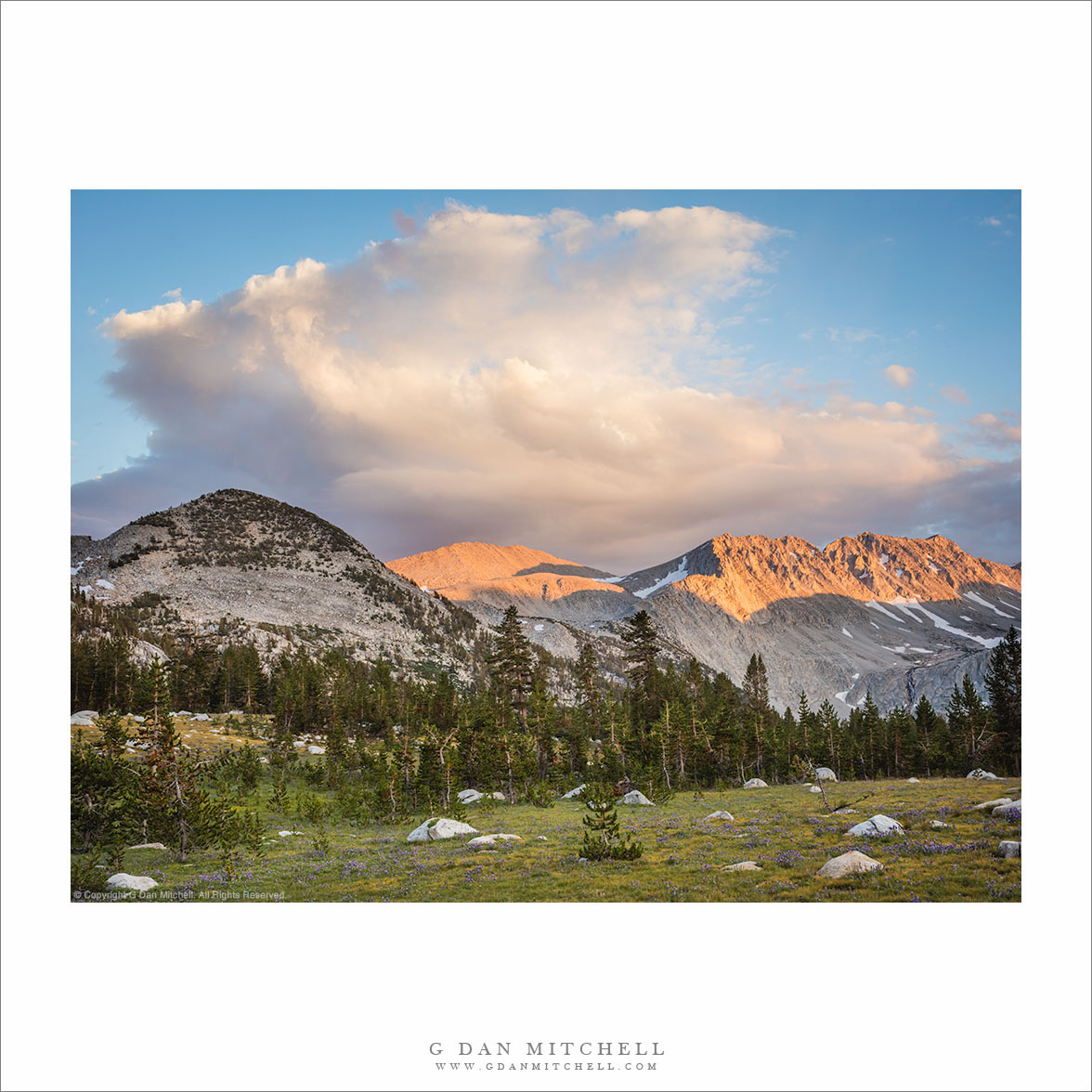
“Alpenglow, Dissipating Thunderhead” — An afternoon thunderstorm dissipates above developing alpenglow on Sierra Nevada peaks and flower-filled meadow, John Muir Wilderness.
I remember this evening well. I’m not always sure why, but the details of certain specific days in the Sierra stick with me. As I recall, it was a quiet evening well into our weeklong stay near the lower end of this high basin. We were relaxed and enjoying the spectacle of large storms dissipating to our south as the evening approached.
These peaks and ridges and this meadow were our friends for that week, and we saw them in diverse conditions and light. Even though it was late summer, the wildflowers peaked near our arrival and were perhaps just beginning to fade. We viewed and photographed that ridge in morning and evening light, on days that were clear and when the view was obstructed by haze, clouds, or rain.
G Dan Mitchell is a California photographer and visual opportunist. His book, “California’s Fall Color: A Photographer’s Guide to Autumn in the Sierra” is available from Heyday Books, Amazon, and directly from G Dan Mitchell.
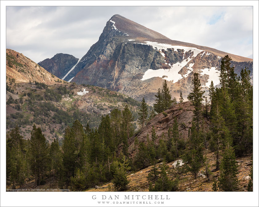
Thunderstorm clouds begin to assemble above Mount Dana, Yosemite National Park
In this case I’ll make a bit of an exception to my usual rule and identify this peak by name. It is Mount Dana, a mountain well-known to folks who pass over Tioga Pass on the eastern boundary of Yosemite National Park, as it towers directly above the pass and is automatically the dominant feature of the landscape here. I climbed it once, many years ago, and have never been up it again, with the exception of one aborted attempt with one of my sons quite a few years ago. (We got up to the edge of the first plateau, only to discover a problem with his shoes.) My single ascent was a formative moment for me in the mountains. I can’t have been much older than 12-14 years old, and I was there with my parents and siblings. There was a ranger-led ascent, and my younger siblings weren’t ready for a 3,000′ climb to slightly over 13,000′, so they sent me alone with the group. (My memory is understandably hazy, but it may have been led by Carl Sharsmith.) I barely recall the summit, but I surely recall the climb, and I have a distinct memory of being at the top and looking down to see some hearty mountaineer type striding straight up the talus slopes across which we had just dragged our non-acclimatized bodies. I was impressed, and that image remains with me.
For such an important peak, it isn’t one I photograph a lot, with the exception of some long-lens photographs from the Tuolumne Meadows area. However, I’m aware of a view alternate views of the mountain, including this one that appeared as I returned from a hike just outside the park. The view from this spot is often a bit bland, frequently in full sun with blue sky. But on this day I was blessed with building clouds that still were broken just enough to let light and shadow move across the face of the peak.
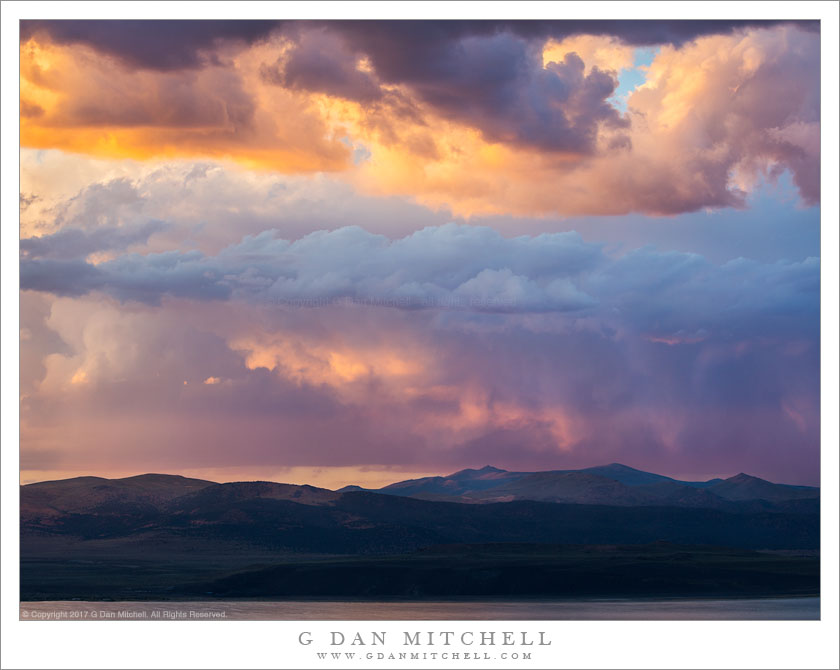
Evening thunderstorm clouds begin to break up above high desert mountains east of the Sierra Nevada at sunset
The Sierra Nevada, being more out of the path of the seasonal monsoonal flows that beset the Southwest, often experiences clear weather — sometimes too clear! Most photographers prefer a more interesting sky, and we can actually be heard complaining about too much nice weather at times. But periodically the atmospheric flows shift northward and westward a bit, and we do see thunderstorm weather in the Sierra. Most of us love this, and we look forward to “interesting skies” when it happens. The clouds often build up over the crest and they can then spread east or sometimes west as the day wears on. Mostly the clouds will clear out late in the day, but sometimes when they drift to the east of the range the electrical show may continue into the evening.
I experienced some of this “interesting weather” on my recent visit to the Sierra around the northeastern portion of Yosemite. It actually turned out to be more interesting than expected, when a forecast of clearing on day two of my trip morphed into a forecast to daily thunderstorm chances. On one afternoon I took a hike up an east side canyon, and on my return I was surprised to find that there was rain falling near the mouth of the canyon. Before long in rained and hailed on me, and these appeared to be the kinds of clouds that might stick around into the evening. I decided to forego dinner, instead finding a high overlook and photographing the cloud show right on through sunset and into the post-sunset blue hour.
Afternoon storm clouds clear from the sunset sky above Lower McCabe Lake, Shepherds Crest, and Virginia Canyon, Yosemite National Park.
With this photograph I get to tell another of the “serendipitous photograph” stories that seem to keep coming up in my work. In this case, we had been camped near the lake in the lower area of the photograph for several days, getting to know the place and having time to carefully photograph various areas nearby. On a previous evening we had climbed to a second lake a few hundred feet higher than the “main” lake, from which one of our group decided to traverse a nearby slope. He ended up at another alpine lake that looked interesting, and the next morning others went with him to visit it. I didn’t, because I had some other things that I wanted to photograph in morning light and because I had a hunch that the light might turn out to be more interesting in the evening, mainly because the area of the lake was open to the west and, therefore, the evening light.
So in the evening, after our typical very early dinner, I departed on a walk to the upper lake that my friends had visited that morning, wandering around “our” lake and through the surrounding forest to pick up a rocky ramp that ascended toward the lake. However, I apparently missed a turn somewhere. I finished the main part of the climb and apparently should have turned left immediately – but I continued on straight ahead and soon found myself in a little meadowy area with a rather steep bunch of rocks between me and my goal. I finally found a circuitous route up a series of ramps, but now it was getting too close to sunset and my turn-around time, so I had to retrace my steps without getting to the lake.
I returned to the small meadow and made a few photographs there, then headed back toward the route by which I had ascended. Despite not making the lake, one of my main goals had been to get up high to photograph the surrounding terrain at sunset, especially since earlier in the day large thunderclouds had been building to the east and creating the possibility of some very special evening light. As I descended the upper part of the “ramp,” the pre-sunset colors started to light up and I quickly found a spot with a good vantage point to view this in several directions. Among the last photographs I made as the light started to fade was the series including this image. (It is actually a composite of two exposures – one for the very bright and saturated clouds and another for the darker shadows down near that lake.) Beyond the lake is the left end of rocky Shepherds Crest and even further in the distance is Virginia Canyon and then the Sierra crest.
(Basic EXIF data may be available by “mousing over” large images in posts when this page is viewed on the web. Leave a comment if you want to know more.)
Photographer and visual opportunist. Daily photos since 2005, plus articles, reviews, news, and ideas.
Manage Consent
To provide the best experiences, we use technologies like cookies to store and/or access device information. Consenting to these technologies will allow us to process data such as browsing behavior or unique IDs on this site. Not consenting or withdrawing consent, may adversely affect certain features and functions.
Functional
Always active
The technical storage or access is strictly necessary for the legitimate purpose of enabling the use of a specific service explicitly requested by the subscriber or user, or for the sole purpose of carrying out the transmission of a communication over an electronic communications network.
Preferences
The technical storage or access is necessary for the legitimate purpose of storing preferences that are not requested by the subscriber or user.
Statistics
The technical storage or access that is used exclusively for statistical purposes.The technical storage or access that is used exclusively for anonymous statistical purposes. Without a subpoena, voluntary compliance on the part of your Internet Service Provider, or additional records from a third party, information stored or retrieved for this purpose alone cannot usually be used to identify you.
Marketing
The technical storage or access is required to create user profiles to send advertising, or to track the user on a website or across several websites for similar marketing purposes.